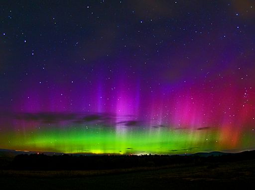
When is the best time to see auroras? Where is the best place to go? And how do you photograph them? These questions and more are answered in a new book, Northern Lights - a Guide, by Pal Brekke & Fredrik Broms. | | | SERVICE OUTAGE: On Sept. 12th, Spaceweather.com was offline for more than 12 hours during the most intense geomagnetic storm of the year. Ironically, the outage was not caused by solar activity. A hardware failure in the network of our Internet service provider brought the web site down at the worst possible time. Webmaster Dr. Tony Phillips apologizes to our readers, alert subscribers, and advertisers for the outage. We are taking steps to make sure this cannot happen again. DOUBLE CME IMPACT SPARKS GEOMAGNETIC STORM: As predicted, a pair of CMEs hit Earth's magnetic field in quick succession on Sept. 11th and 12th. The result was a G3-class geomagnetic storm, the most intense of the year so far. At the peak of the storm on Sept 12-13, bright auroras ringed the Arctic Circle and spilled down over several northern-tier US states. The sky over Maine exploded in a rainbow of colors: 
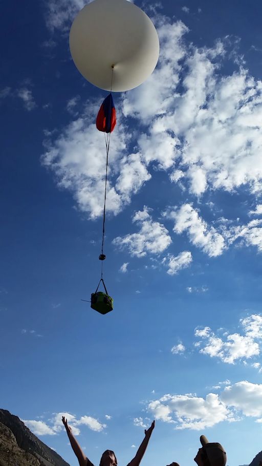
"I took the picture from Casco, Maine, facing north towards the Presidential Range in New Hampshire," says photographer John Stetson. "Red, purple, green, blue--all the colors were there!" The storm is subsiding now. Nevertheless, high-latitude sky watchers should remain alert for auroras. NOAA forecasters estimate a whopping 90% chance of additional polar geomagetic activity on Sept. 13th as Earth passes through the wake of the double CME. Aurora alerts: text, voice Realtime Aurora Photo Gallery SPACE WEATHER PROBE LAUNCHED: While the web site Spaceweather.com was down during the most intense geomagnetic storm of the year, the webmaster shook off the stress by going outside ... and launching a space weather probe. Carried aloft by a helium balloon, the probe was prepared and released by the students of Earth to Sky Calculus just as the planetary K-index hit 7during the waning hours of Sept. 12th: 
Inside the balloon's payload, there was a high-energy radiation sensor, a cryogenic thermometer, multiple GPS altimeters and trackers, and three cameras to record the flight. The launch was the latest in an ongoing series of suborbital balloon flights to measure the effect of stormy space weather on Earth's atmosphere from ground level to the stratosphere. Soon, the group will release an entire year's worth of data of interest to commercial aviation and space tourism. After a 2.5 hour flight, the payload has parachuted back to Earth and landed in the Inyo Mountains of central California. A student team will recover the payload and its sensors this weekend. Stay tuned. Realtime Space Weather Photo Gallery
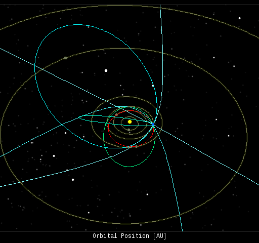
Realtime Comet Photo Gallery Every night, a network of NASA all-sky cameras scans the skies above the United States for meteoritic fireballs. Automated software maintained by NASA's Meteoroid Environment Office calculates their orbits, velocity, penetration depth in Earth's atmosphere and many other characteristics. Daily results are presented here on Spaceweather.com. On Sep. 13, 2014, the network reported 253 fireballs.
(250 sporadics, 3)  In this diagram of the inner solar system, all of the fireball orbits intersect at a single point--Earth. The orbits are color-coded by velocity, from slow (red) to fast (blue). [Larger image] [movies] Potentially Hazardous Asteroids ( PHAs) are space rocks larger than approximately 100m that can come closer to Earth than 0.05 AU. None of the known PHAs is on a collision course with our planet, although astronomers are finding new ones all the time. On September 13, 2014 there were 1500 potentially hazardous asteroids. Notes: LD means "Lunar Distance." 1 LD = 384,401 km, the distance between Earth and the Moon. 1 LD also equals 0.00256 AU. MAG is the visual magnitude of the asteroid on the date of closest approach. | | The official U.S. government space weather bureau | | | The first place to look for information about sundogs, pillars, rainbows and related phenomena. | | | Researchers call it a "Hubble for the sun." SDO is the most advanced solar observatory ever. | | | 3D views of the sun from NASA's Solar and Terrestrial Relations Observatory | | | Realtime and archival images of the Sun from SOHO. | | | from the NOAA Space Environment Center | | | the underlying science of space weather | | 
