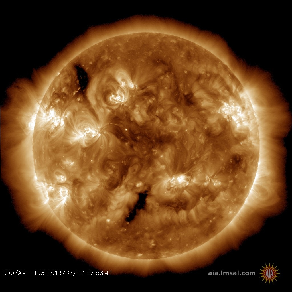
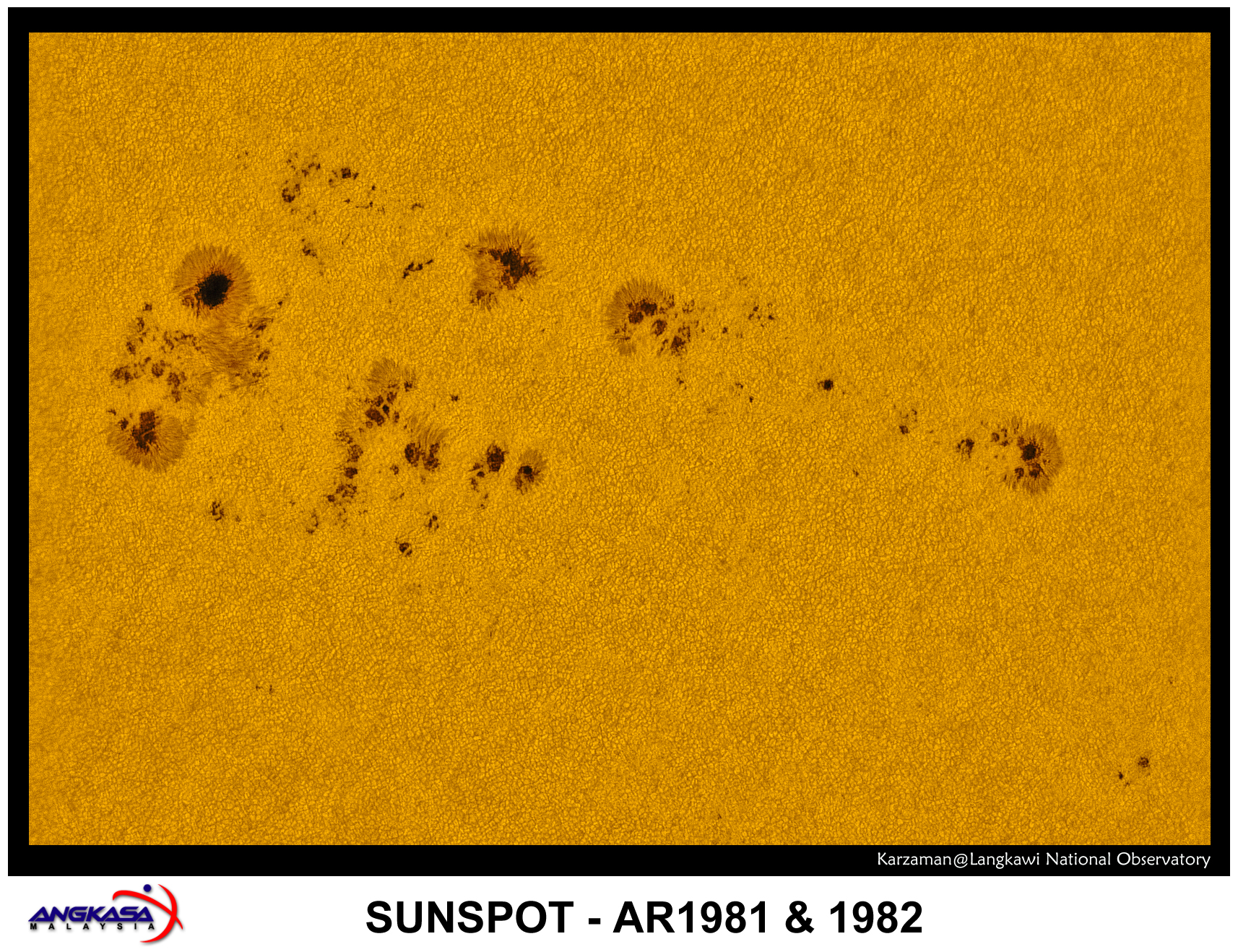
Listen to radar echoes from satellites and meteors, live on listener-supported Space Weather Radio. | | | CHANCE OF MINOR STORMS: NOAA forecasters estimate a 50% chance of minor geomagnetic storms on Sunday, Feb. 23rd, in response to glancing blows from one or two incoming CMEs. Arctic sky watchers should remain alert for auroras. Aurora alerts: text, voice SPRAWLING SUNSPOT FACES EARTH: Occupying an expanse of solar terrain more than 280,000 km wide, sunspot complex AR1981-AR1982 is crossing the center of the solar disk, almost-directly facing Earth. This morning at the Langkawi National Observatory in Malaysia, astronomer Karzaman Ahmad photographed the behemoth: 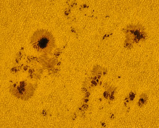
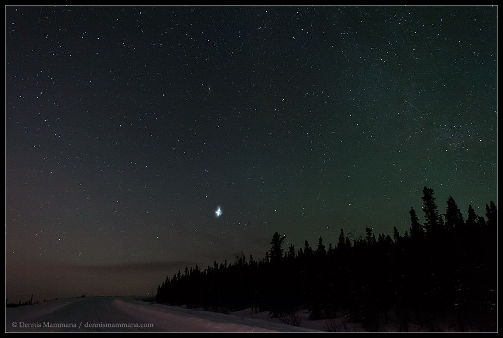
Because it's so wide, the entire sunspot complex would not fit on the page. Click here to see the whole thing. Dozens of dark cores are present in Ahmad's image. The largest ones are about the size of Earth. Also note the fine granulation of the solar surface. Those are Texas-sized bubbles of plasma rising and falling around the sunspots like water boiling on top of a hot stove. The magnetic canopy of AR1981-AR1982 harbors energy for significant eruptions. NOAA forecasters estimate a 50% chance of M-class flares and a 5% chance of X-class flares on Feb. 23rd. Solar flare alerts: text, voice Realtime Space Weather Photo Gallery MYSTERY CLOUD (DE-MYSTIFIED): On the night of Feb. 20/21, photographer Dennis Mammana was stationed on Pedro Dome near Fairbanks, Alaska, in hopes of recording the Northern Lights. "I caught this instead—a tiny and bright cloud that rose from the western sky and spread slightly and faded over an hour or so," says Mammana. Here is a composite of two of his shots:
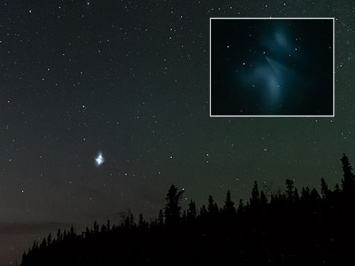
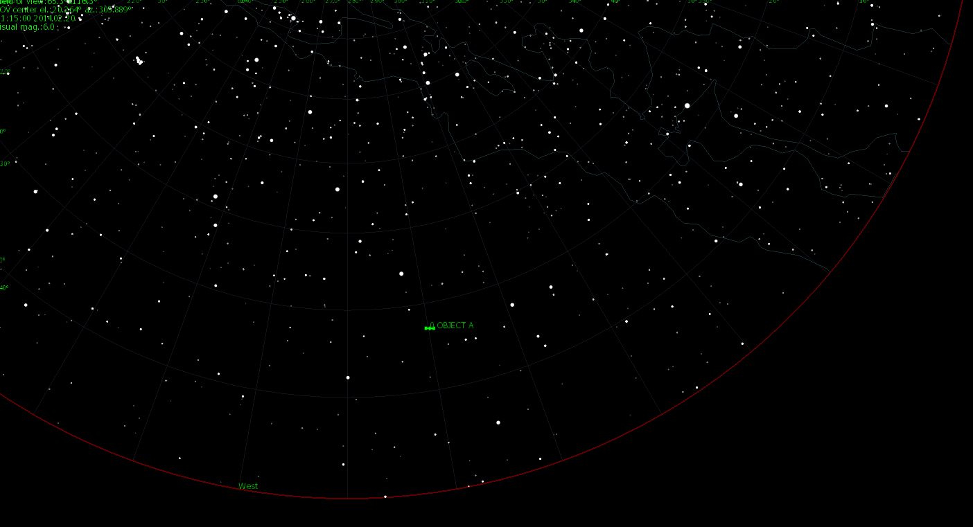
The cloud resembles a rocket fuel dump. Scientists from the University of Alaska frequently launch rockets from the nearby Poker Flat Research Range to study auroras. But on this night there were no rocket launches on Poker Flat. Update: There was, however, a launch thousands of miles away. A Delta 4 rocket blasted off from Cape Canaveral carrying a GPS satellite. Veteran satellite watcher Marco Langbroek of the Netherlands says this is it: "The mystery object on the Mammana photo is a fuel vent from the Feb 20 launch of GPS 2F-05 (USA 248, 20114-008A, #39533)." "Although the satellite is in an orbit with a 54.98 degree inclination, that does not mean it was not visible from Mammana's location at 65N," he continues. "It is in a very high orbit and was at an altitude of over 20,000 km at the time of the photo. At such an altitude it is visible from 65 N, low in the west in this case." A sky map prepared by Langbroek shows the position of the satellite (labeled "Object A") in the sky above Alaska when Mammana saw the cloud. The sky map and the photo are a good match. Update #2: Another sighting of the cloud has been reported, by David Cartier, Sr. located 30 km. east of Whitehorse, Yukon, Canada. Click here to see his photo. Realtime Aurora Photo Gallery
Realtime Comet Photo Gallery
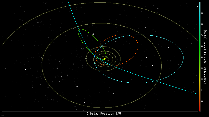
Every night, a network of NASA all-sky cameras scans the skies above the United States for meteoritic fireballs. Automated software maintained by NASA's Meteoroid Environment Office calculates their orbits, velocity, penetration depth in Earth's atmosphere and many other characteristics. Daily results are presented here on Spaceweather.com. On Feb. 23, 2014, the network reported 4 fireballs.
(4 sporadics) 
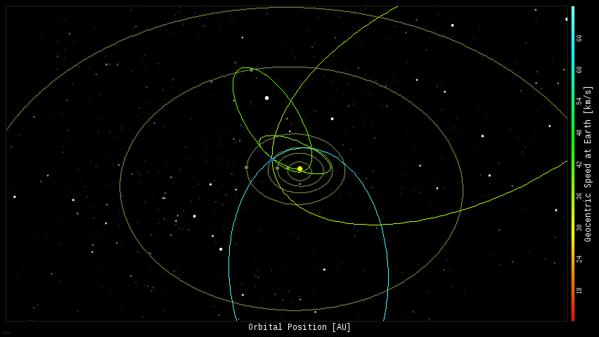
In this diagram of the inner solar system, all of the fireball orbits intersect at a single point--Earth. The orbits are color-coded by velocity, from slow (red) to fast (blue). [Larger image] [movies] On Feb. 22, 2014, the network reported 5 fireballs.
(5 sporadics) 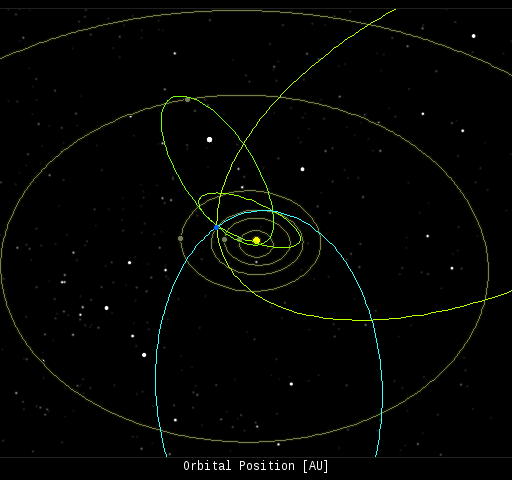
In this diagram of the inner solar system, all of the fireball orbits intersect at a single point--Earth. The orbits are color-coded by velocity, from slow (red) to fast (blue). [Larger image] [movies]
Potentially Hazardous Asteroids ( PHAs) are space rocks larger than approximately 100m that can come closer to Earth than 0.05 AU. None of the known PHAs is on a collision course with our planet, although astronomers are finding new ones all the time. On February 23, 2014 there were 1458 potentially hazardous asteroids. Notes: LD means "Lunar Distance." 1 LD = 384,401 km, the distance between Earth and the Moon. 1 LD also equals 0.00256 AU. MAG is the visual magnitude of the asteroid on the date of closest approach. | | The official U.S. government space weather bureau | | | The first place to look for information about sundogs, pillars, rainbows and related phenomena. | | | Researchers call it a "Hubble for the sun." SDO is the most advanced solar observatory ever. | | | 3D views of the sun from NASA's Solar and Terrestrial Relations Observatory | | | Realtime and archival images of the Sun from SOHO. | | | from the NOAA Space Environment Center | | | the underlying science of space weather | | 


