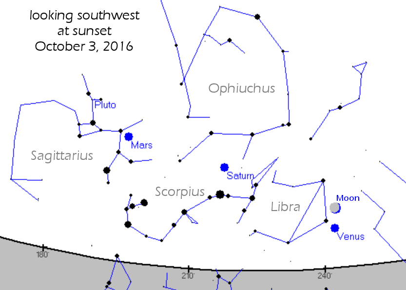
Directly under the Arctic Circle! Marianne's Arctic Xpress in Tromsø offers fjord, whale and wildlife tours by day, aurora tours by night. Book Now and get a 10% discount on combo day and night adventures. | | | SUNSET SKY SHOW: When the sun goes down tonight, step outside and look west. An exquisitely slender crescent Moon is passing by Venus in the rosy glow of sunset. A clear view of the horizon is essential, as both are hanging low. [sky map] SPRITES ABOVE HURRICANE MATTHEW: On Oct. 1st, Earth weather met space weather above Hurricane Matthew. As the giant storm system was approaching the Greater Antilles, Frankie Lucena of Puerto Rico photographed red sprites shooting up from the thunderclouds: 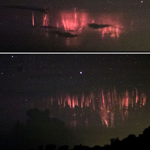
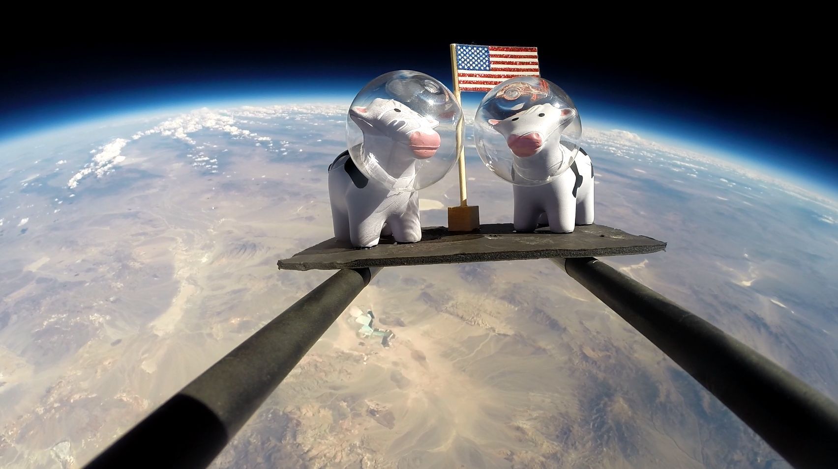
Sprites are a strange and beautiful form of lightning that shoot up from the tops of electrical storms. They reach all the way up to the edge of space alongside meteors, auroras, and noctilucent clouds. Some researchers believe cosmic rays help trigger sprites, making them a true space weather phenomenon. Seeing sprites above a hurricane is rare. Many hurricanes don't even have regular lightning because the storms lack a key ingredient for electrical activity: vertical winds. (For more information read the Science@NASA article "Electric Hurricanes.") But Matthew is not a typical hurricane. It's one of the most powerful in recent years, briefly reaching Category 5 at about the time Lucena photographed the sprites. Perhaps extra-strong winds in the vicinity of the storm set the stage for upward-reaching bolts. Sprite photographers across the Caribbean and the southeastern USA should be alert for more as the storm system approaches the mainland: observing tips. Realtime Sprite Photo Gallery ONE SMALL STEP FOR A COW... On Oct. 1st, Spaceweather.com and the students of Earth to Sky Calculus launched a space weather balloon to monitor cosmic rays in the stratosphere. The flight was sponsored by these cows: 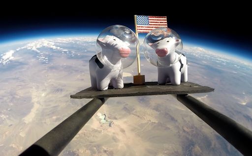
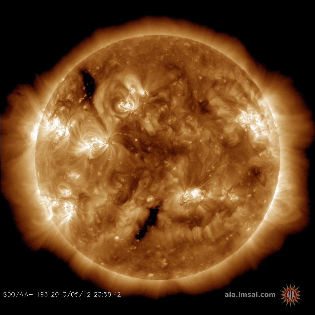
The space traveling bovines are mascots of Dairyland Electrical Industries, the world's leading manufacturer of solid-state decoupling products. Dairyland's generous donation to our student research program paid for all the supplies necessary to get the payload of cows and radiation sensors off the ground. In exchange, they'll receive a complete HD video of the flight to use for marketing and other purposes. Business owners, if you would like to contribute to a growing body of knowledge about atmospheric radiation and see your own marketing item at the edge of space, please contact Dr. Tony Phillips to sponsor a flight. Sponsorships are currently available for flights scheduled on Oct. 18th, Nov. 6th, 12th, and 20th. Realtime Space Weather Photo Gallery WHO NEEDS SUNSPOTS? It is widely thought that auroras require sunspots. Explosions in the magnetic canopies of sunspots can trigger geomagnetic storms and beautiful Arctic Lights. In fact, sunspots are not required. Behold this display, which appeared over Lohtaja, Finland, on Oct. 2nd when the sunspot number was near zero: 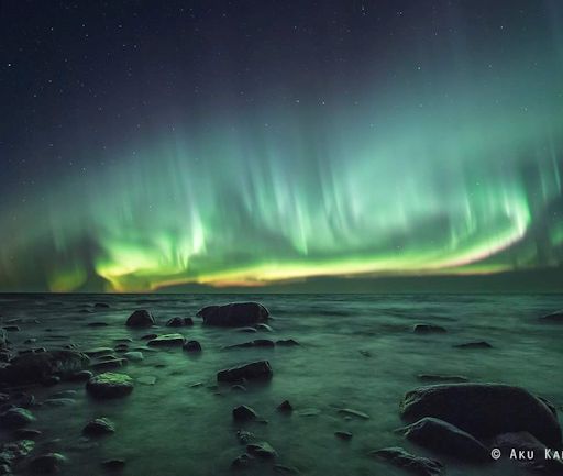
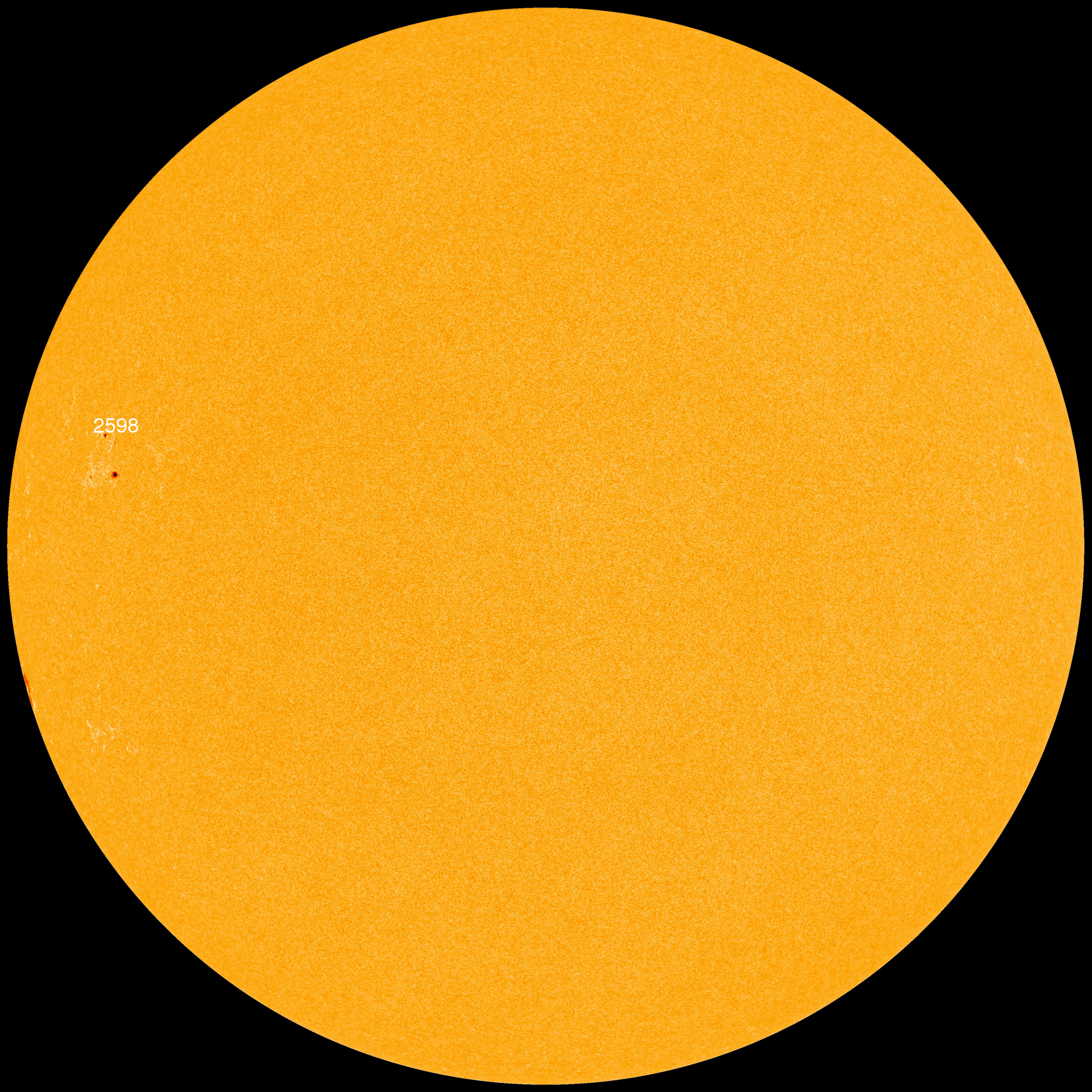
"Bright auroras appeared around 11pm local time," says photographer Aku Kankaanpää. "The lights didn't last very long, but they lit up the stormy sea and seashore stones." The cause of the display was a stream of solar wind, which has been pressing against Earth's magnetic field for days. The pressure is igniting intermittent geomagnetic storms and auroras around the Arctic Circle. The sunspot number is still low on Oct 3rd. Nevertheless, more auroras are possible tonight as the solar wind continues to blow. Realtime Aurora Photo Gallery
| | Cosmic Rays in the Atmosphere |
Updated: Sept. 29 2016 // Next Flight: Oct. 1, 2016
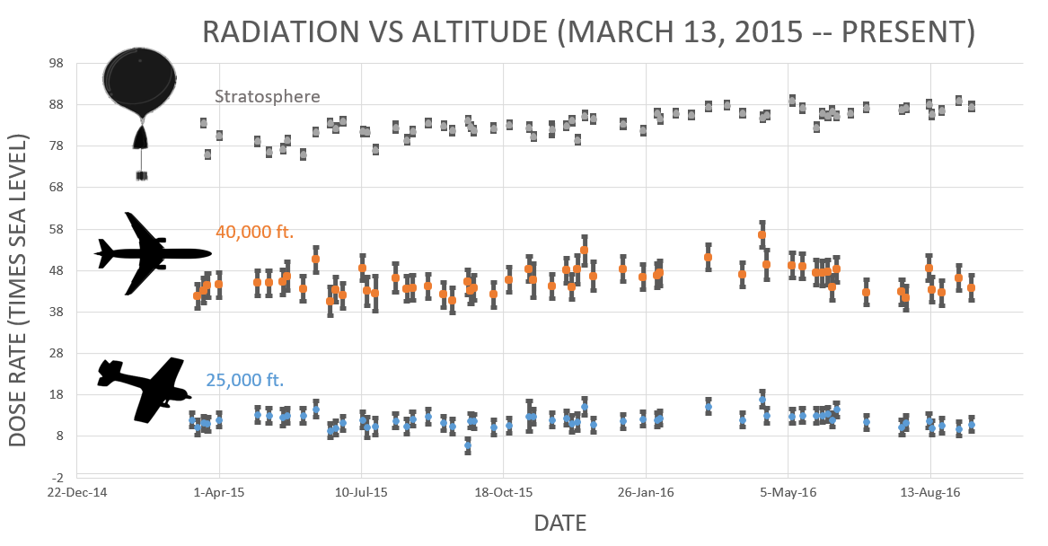
Sept. 20, 2016: Readers, thank you for your patience while we continue to develop this new section of Spaceweather.com. We've been working to streamline our data reduction, allowing us to post results from balloon flights much more rapidly, and we have developed a new data product, shown here: 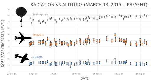
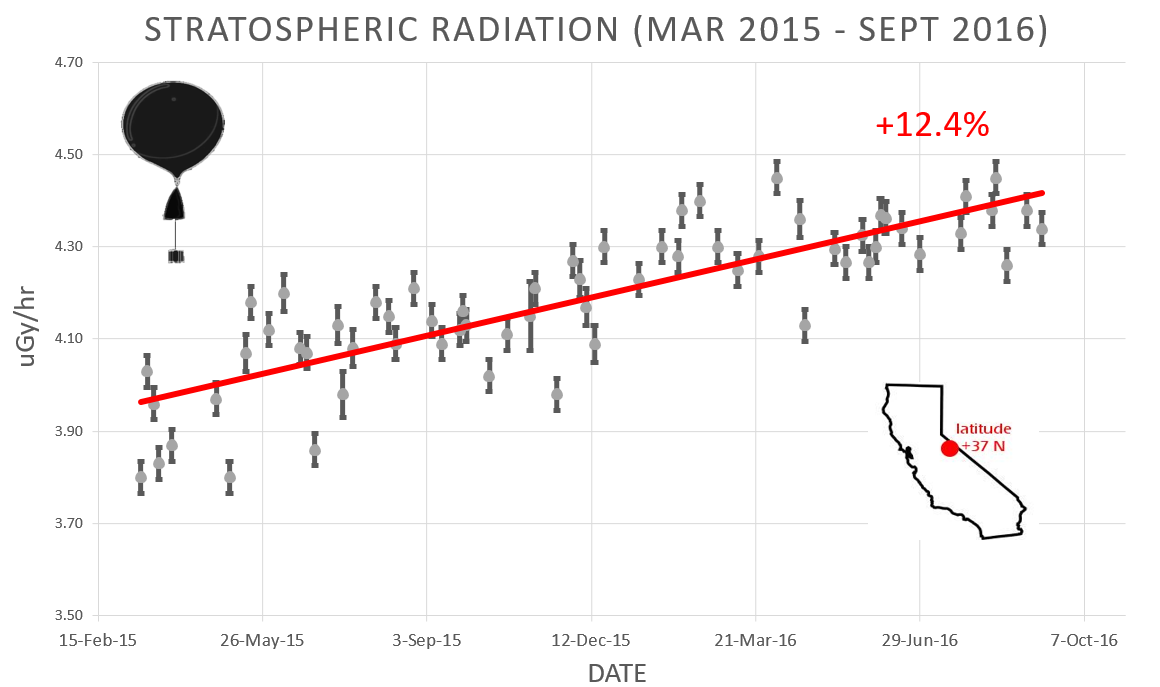
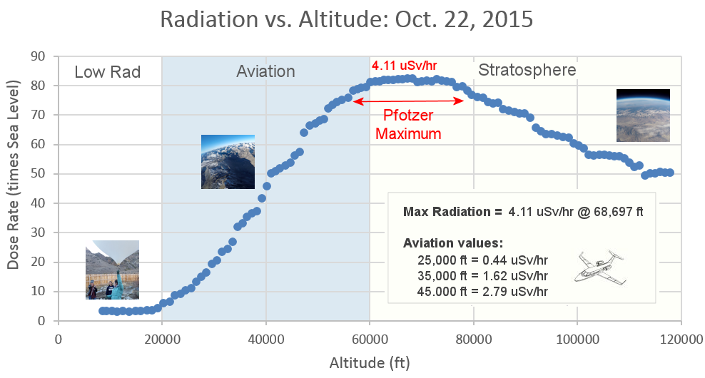
This plot displays radiation measurements not only in the stratosphere, but also at aviation altitudes. Dose rates are expessed as multiples of sea level. For instance, we see that boarding a plane that flies at 25,000 feet exposes passengers to dose rates ~10x higher than sea level. At 40,000 feet, the multiplier is closer to 50x. These measurements are made by our usual cosmic ray payload as it passes through aviation altitudes en route to the stratosphere over California. What is this all about? Approximately once a week, Spaceweather.com and the students of Earth to Sky Calculus fly space weather balloons to the stratosphere over California. These balloons are equipped with radiation sensors that detect cosmic rays, a surprisingly "down to Earth" form of space weather. Cosmic rays can seed clouds, trigger lightning, and penetrate commercial airplanes. Furthermore, there are studies ( #1, #2, #3, #4) linking cosmic rays with cardiac arrhythmias and sudden cardiac death in the general population. Our latest measurements show that cosmic rays are intensifying, with an increase of more than 12% since 2015: 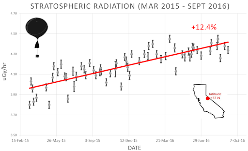
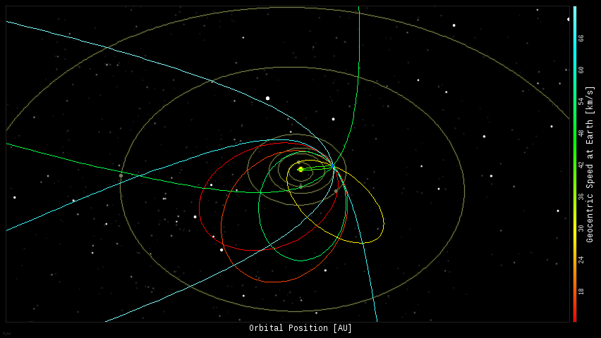
Why are cosmic rays intensifying? The main reason is the sun. Solar storm clouds such as coronal mass ejections (CMEs) sweep aside cosmic rays when they pass by Earth. During Solar Maximum, CMEs are abundant and cosmic rays are held at bay. Now, however, the solar cycle is swinging toward Solar Minimum, allowing cosmic rays to return. Another reason could be the weakening of Earth's magnetic field, which helps protect us from deep-space radiation. The radiation sensors onboard our helium balloons detect X-rays and gamma-rays in the energy range 10 keV to 20 MeV. These energies span the range of medical X-ray machines and airport security scanners. The data points in the graph above correspond to the peak of the Reneger-Pfotzer maximum, which lies about 67,000 feet above central California. When cosmic rays crash into Earth's atmosphere, they produce a spray of secondary particles that is most intense at the entrance to the stratosphere. Physicists Eric Reneger and Georg Pfotzer discovered the maximum using balloons in the 1930s and it is what we are measuring today. Every night, a network of NASA all-sky cameras scans the skies above the United States for meteoritic fireballs. Automated software maintained by NASA's Meteoroid Environment Office calculates their orbits, velocity, penetration depth in Earth's atmosphere and many other characteristics. Daily results are presented here on Spaceweather.com. On Oct. 3, 2016, the network reported 9 fireballs.
(8 sporadics, 1 Southern Taurid) 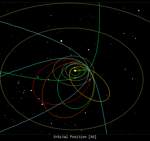 In this diagram of the inner solar system, all of the fireball orbits intersect at a single point--Earth. The orbits are color-coded by velocity, from slow (red) to fast (blue). [Larger image] [movies] Potentially Hazardous Asteroids ( PHAs) are space rocks larger than approximately 100m that can come closer to Earth than 0.05 AU. None of the known PHAs is on a collision course with our planet, although astronomers are finding new ones all the time. On October 3, 2016 there were potentially hazardous asteroids. Notes: LD means "Lunar Distance." 1 LD = 384,401 km, the distance between Earth and the Moon. 1 LD also equals 0.00256 AU. MAG is the visual magnitude of the asteroid on the date of closest approach. | | The official U.S. government space weather bureau | | | The first place to look for information about sundogs, pillars, rainbows and related phenomena. | | | Researchers call it a "Hubble for the sun." SDO is the most advanced solar observatory ever. | | | 3D views of the sun from NASA's Solar and Terrestrial Relations Observatory | | | Realtime and archival images of the Sun from SOHO. | | | from the NOAA Space Environment Center | | | a proud supporter of science education and Spaceweather.com | | | the underlying science of space weather |  | Find homes for sale in Ocala, Orlando and Tampa with the #1 real estate company in Central Florida Local Realty Service | | Visit Need An Eitzah for all your questions and forum discussions on Jewish life. | | | These links help Spaceweather.com stay online. Thank you to our supporters! | | 


