Learn to photograph Northern Lights like a pro. Sign up for Peter Rosen's Aurora Photo Courses in Abisko National Park, winner of the TripAdvisor Certificate of Excellence Award 2015. | | |
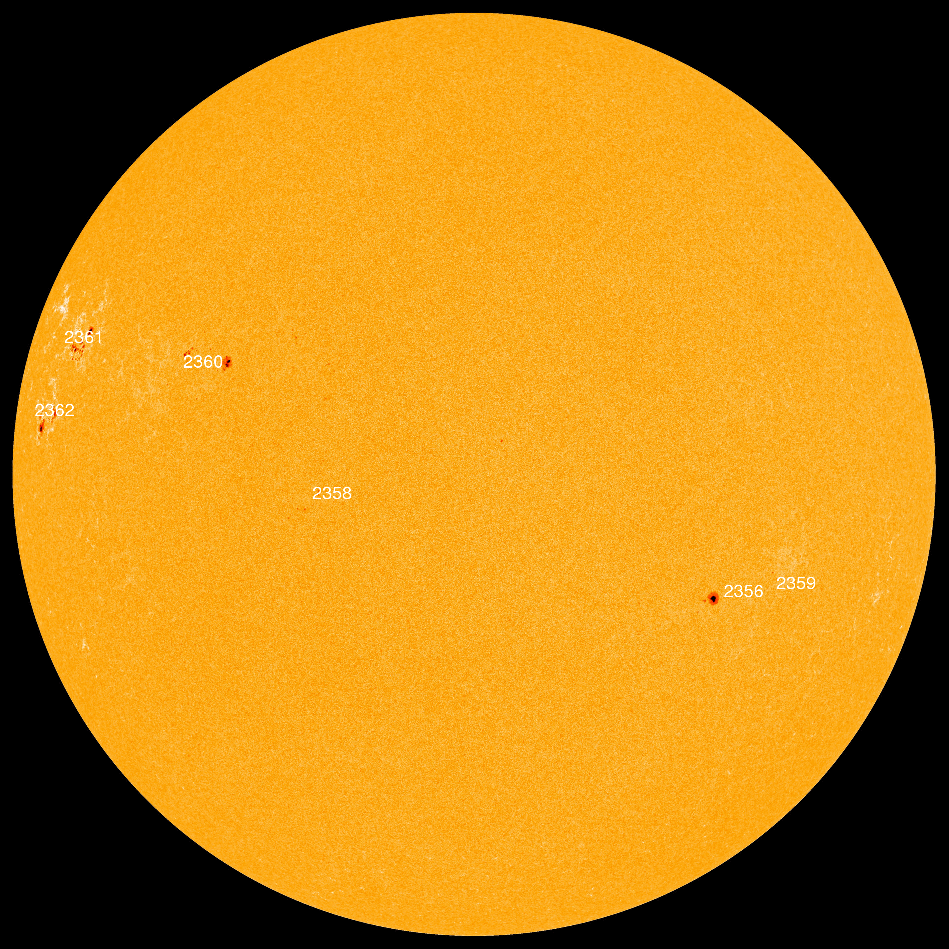
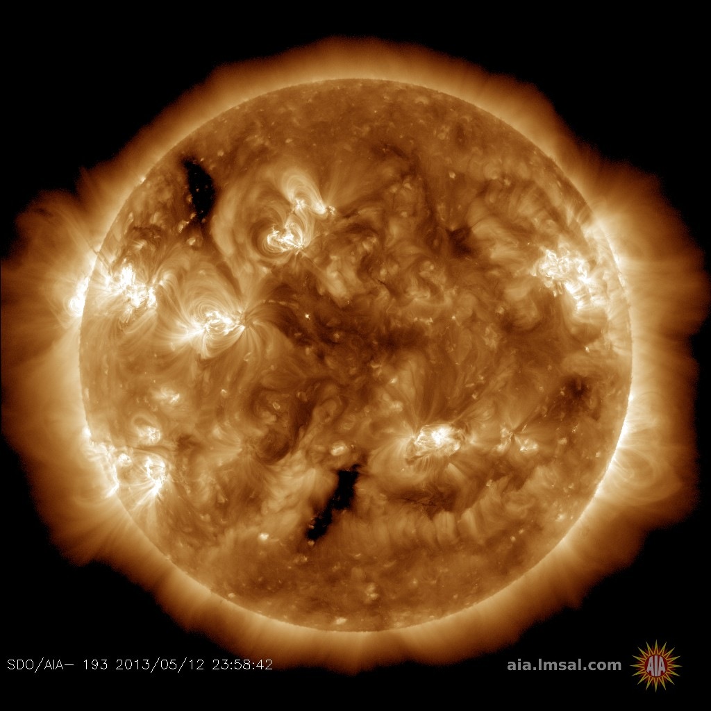
INCREASING CHANCE OF FLARES: Prompted by the emergence of two new sunspots, NOAA forecasters have boosted the odds of an M-class flare today to 20%. The most likely source of an eruption is AR2361 near the sun's northeastern limb. Solar flare alerts: text, voice
NOCTILUCENT CLOUDS HOP THE ATLANTIC: In 2015, the first reports of noctilucent clouds (NLCs) came from Europe. Now the clouds have hopped the Atlantic, and Canadians are seeing them, too. "Despite the full Moon in the opposite part of the sky, the NLC display was quite noticeable," reports Alister Ling, who sends this picture from Edmonton, Alberta:
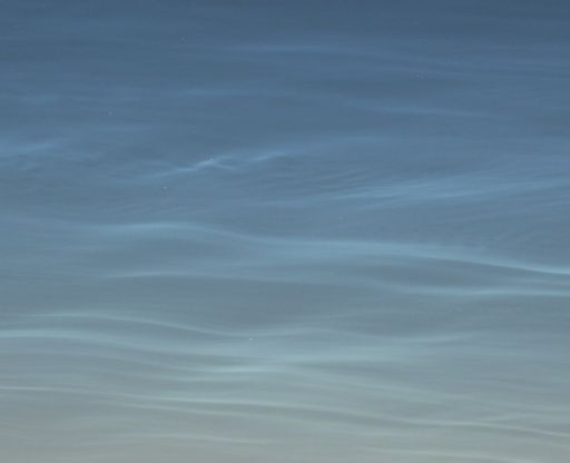
"To confirm it was not moonlit cirrus, I examined the clouds through binoculars," says Ling. "The classic waves and bands of NLCs are just gorgeous in binoculars."
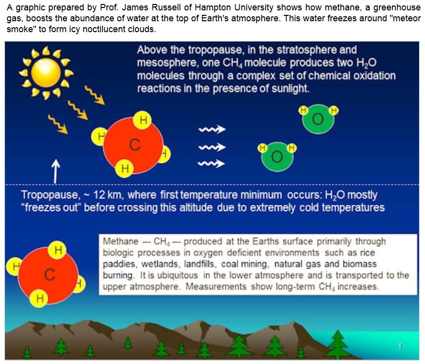
NLCs are Earth's highest clouds. Seeded by meteoroids, they float at the edge of space more than 80 km above the planet's surface. The clouds are very cold and filled with tiny ice crystals. When sunbeams hit those crystals, they glow electric-blue.
Noctilucent clouds first appeared in the 19th century after the eruption of super-volcano Krakatoa. At the time, people thought NLCs were caused by the eruption, but long after Krakatoa's ash settled, the clouds remained. In recent years, NLCs have intensified and spread with summer sightings as far south as Utah and Colorado. This could be a sign of increasing greenhouse gases in Earth's atmosphere.
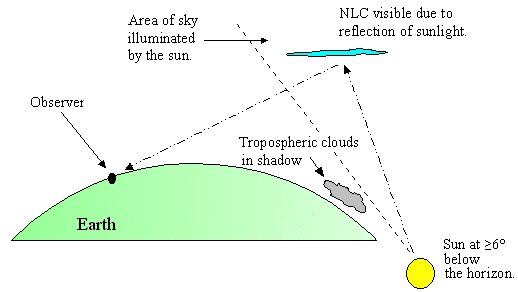
Observing tips: Look west 30 to 60 minutes after sunset when the Sun has dipped 6o to 16o below the horizon. If you see luminous blue-white tendrils spreading across the sky, you may have spotted a noctilucent cloud.
Realtime NLC Photo Gallery
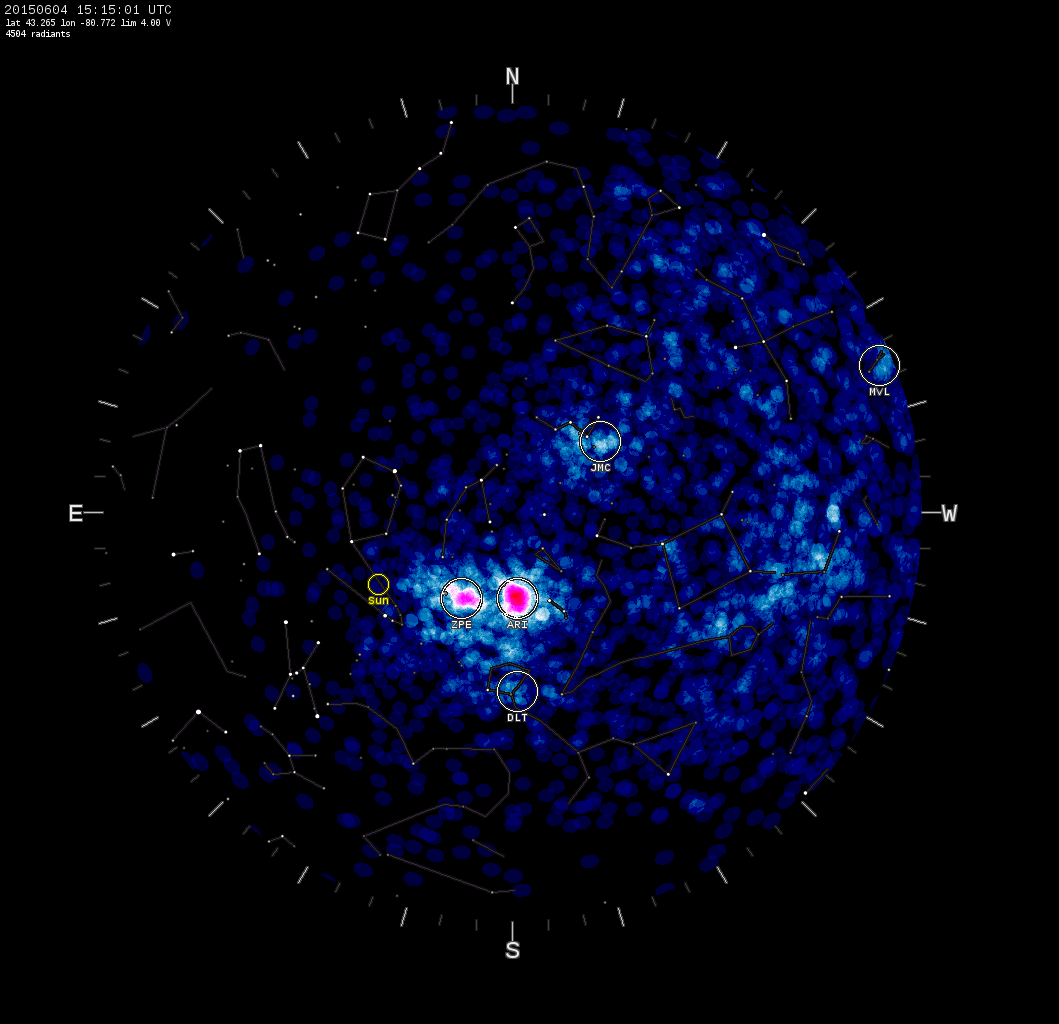
DAYLIGHT METEOR SHOWER: On June 4th, the Canadian Meteor Orbit Radar (CMOR) detected a surge in meteor activity. "CMOR has begun to see the ramp up of the Daytime Arietid shower," reports Peter Brown of the University of Western Ontario. The pink "hot spot" in this CMOR sky map shows how the radar echoes are clustered in the constellation Aries--not far from the glaring sun:
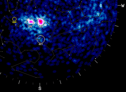
"The Arietids are the fifth strongest shower of the year detected by CMOR," says Brown. "They are likely related to a complex of debris streams produced during the breakup of a large comet several millennia ago."
Ironically, most people never notice this relatively intense shower. The reason: It peaks in broad daylight. Compared to the human eye, radars do a much better job detecting meteors through the glare.
"Visual observers may be able to see a handful of Arietids in the hour or so before sunrise over the next week when the shower is at its peak," notes Brown. "These will all be 'Earthgrazers'--that is, meteors which enter at shallow (<10o) angles and streak across very long arcs in the sky. This peculiar visibility is a result of the radiant never getting much above the horizon at northern latitudes before the rising sun washes out the show."
"The shower is unique among CMOR streams in that it has a very broad peak lasting almost five days," adds Brown. "The best time to watch will be any day during the early morning hours of June 6 – June 12."
Extra: Listen to the Arietids on Space Weather Radio!
Realtime Meteor Photo Gallery
SPACE STATION MARATHON: The annual "space station marathon" is underway. For the next few weeks, the ISS will be almost continuously lit by summer sunlight when it passes over our planet's northern hemisphere. Sky watchers can see the space station gliding among the stars as often as four times every night. On June 3rd, Philip Smith photographed one of several flybys over his backyard in Manorville, New York:
"It was very cloudy during the flyby," he says,"but using my telescope I was able to catch the ISS through a small gap in the clouds almost directly overhead."
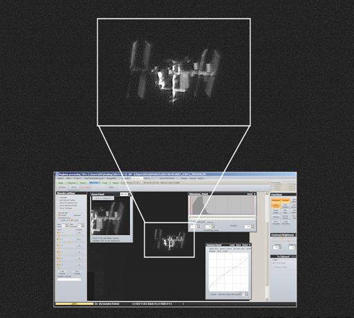
To the unaided eye the ISS looks like a bright slow-moving star, often rivaling Jupiter or Venus in luminosity. Small telescopes trained on the spaceship reveal its sprawling solar arrays, labs and living quarters, and retinue of docked supply ships. Smith sharpened these details by aligning and "stacking" multiple video frames. "In this screenshot, I share a part of how I processed this stacked image using RegiStax 5."
Ready to see the ISS for yourself? There are plenty of chances as summer nears. Find out when to look using Spaceweather.com's Simple Satellite Tracker.
Realtime Space Weather Photo Gallery
Realtime Sprite Photo Gallery
Realtime Aurora Photo Gallery
Every night, a network of NASA all-sky cameras scans the skies above the United States for meteoritic fireballs. Automated software maintained by NASA's Meteoroid Environment Office calculates their orbits, velocity, penetration depth in Earth's atmosphere and many other characteristics. Daily results are presented here on Spaceweather.com.
On Jun. 5, 2015, the network reported 3 fireballs.
(3 sporadics)
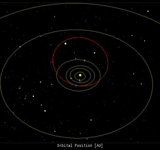
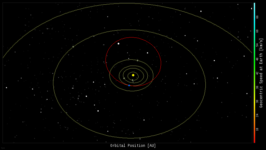
In this diagram of the inner solar system, all of the fireball orbits intersect at a single point--Earth. The orbits are color-coded by velocity, from slow (red) to fast (blue). [Larger image] [movies]
Potentially Hazardous Asteroids (
PHAs) are space rocks larger than approximately 100m that can come closer to Earth than 0.05 AU. None of the known PHAs is on a collision course with our planet, although astronomers are finding
new ones all the time.
On June 5, 2015 there were potentially hazardous asteroids.
Notes: LD means "Lunar Distance." 1 LD = 384,401 km, the distance between Earth and the Moon. 1 LD also equals 0.00256 AU. MAG is the visual magnitude of the asteroid on the date of closest approach. | | The official U.S. government space weather bureau |
| | The first place to look for information about sundogs, pillars, rainbows and related phenomena. |
| | Researchers call it a "Hubble for the sun." SDO is the most advanced solar observatory ever. |
| | 3D views of the sun from NASA's Solar and Terrestrial Relations Observatory |
| | Realtime and archival images of the Sun from SOHO. |
| | from the NOAA Space Environment Center |
| | the underlying science of space weather |
| | Web-based high school science course with free enrollment |


