Based in Tromsø directly under the Arctic Circle, Marianne's Arctic Xpress offers a comfortable 7 seater minivan for aurora, fjord, whale, and wildlife tours day and night. 100% PASSION and a very high % of finding aurora. Book Now | | |
AN UPTICK IN SOLAR FLARE ACTIVITY: Two new sunspots are rapidly emerging on the solar disk, and one of them (AR2615) is crackling with C- and M-class solar flares. So far the eruptions are minor. However, they do represent a noteable uptick in activity compared to the absolute quiet of recent months. Free: Solar flare alerts.
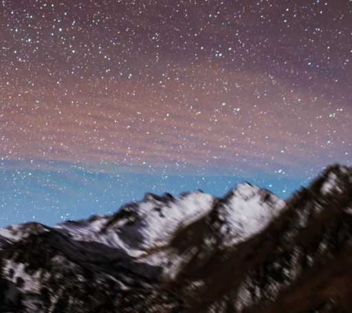
MESOSPHERIC BORE (IT'S NOT WHAT YOU THINK): This month, a lot is happening in the mesosphere. The mesosphere is a layer of Earth's atmosphere above the stratosphere; it is the realm of sprites, noctilucent clouds (NLCs), and airglow. Starting on Nov. 17th, NASA's AIM spacecraft spotted bright noctilucent clouds forming in the mesosphere above Antarctica. Then, in an apparently unrelated development on Nov. 24th, the normal dome of airglow over China split in two. Xiao Shuai photographed the event from Mount Balang in Sichuan:
This is called a "mesospheric bore"--and not because it's dull. A bore is a type of atmospheric wave with deep ripples at its leading edge. Indeed, you can see the ripples in Shuai's photo separating the zone of airglow from clear sky.
Bores fall into the category of "gravity waves"—so called because gravity acts as the restoring force essential to wave motion. Analogy: Boats in water. When a boat goes tearing across a lake, water in front of the boat is pushed upward. Gravity pulls the water back down again and this sets up a wave.
In this case, instead of water, rarefied air is the medium through which the wave propagates. The sudden boundary in the airglow layer is probably akin to a hydraulic jump. But what created the disturbance in the first place? (What is the 'boat'?) No one knows.
"There may be more updates in the coming days as scientists from NASA and the Chinese Academy of Science check data from satellites to learn more about this event," says Jeff Dai, who has been helping Xiao Shuai process and communicate his extraordinary images. Stay tuned.
NOCTILUCENT CLOUDS APPEAR OVER ANTARCTICA: This just in from NASA's AIM spacecraft: The sky above Antarctica is glowing electric blue. A ring of bright noctilucent clouds (NLCs) has formed around the South Pole, shown here in a Nov. 24th image taken by the spacecraft's Cloud Imaging and Particle Size (CIPS) Instrument:

"This season started on Nov. 17th, and is tied with 2013 for the earliest southern hemisphere season in the CIPS data record," says Cora Randall, a member of the AIM science team at the University of Colorado.
NLCs are Earth's highest clouds. They form more than 80 km above Earth's surface. Indeed, they are a mixture of Earth and space: Wisps of summertime water vapor rising from the planet below wrap themselves around meteoroids, forming tiny crystals of ice. Emphasis on summertime; NLCs appear on the eve of summer in both hemispheres.
There is growing evidence that noctilucent clouds are boosted by climate change. In recent years they have been sighted at lower latitudes than ever before, and they often get started in earlier months as well.
"The early start of the 2016 season was not at all a surprise," says Randall. "The southern hemisphere polar stratospheric winds switched to their summer-like state quite early this year."
Readers, you can monitor developments over Antarctica right here on Spaceweather.com. "Daily daisies" from NASA's AIM spacecraft are automatically posted every 24 hours, showing the dance of electric-blue around the frozen continent.
Realtime Noctilucent Cloud Photo Gallery
BUY A TICKET TO THE EDGE OF SPACE: Christmas shopping for a young scientist? Consider this: For the holiday season only, we're reducing the cost of payload space on Earth to Sky Calculus balloons from $500 to only $299.95. Buy an edge of space gift certificate before Dec. 25th and your student can send an experiment, photo, or keepsake item to the stratosphere, completely supported by an Earth to Sky Calculus launch and recovery team.

This is not only a great Christmas gift, but also a good kickstarter for science fair projects. Experiments will be flown and returned along with video footage, GPS tracking, temperature, pressure, altimetry and radiation data.
To take advantage of the discounted rate, payment must be received before Dec. 25th. However, the flight can take place at any time in the next 12 months.
Conditions: No mammals. Plants and non-pathogenic microbes are allowed. Generally speaking, experiments should weigh less than ~300 grams and occupy a volume less than ~64 cubic inches. A Skype brainstorming session is included with each certificate. Dr. Tony Phillips and other members of the Earth to Sky team will chat with students to help them craft an experiment that will work in the harsh environment of the stratosphere.
More edge of space Christmas gifts may be found in the Earth to Sky Store.
Realtime Space Weather Photo Gallery
Realtime Sprite Photo Gallery
Realtime Aurora Photo Gallery
Realtime Airglow Photo Gallery
Every night, a network of
NASA all-sky cameras scans the skies above the United States for meteoritic fireballs. Automated software maintained by NASA's Meteoroid Environment Office calculates their orbits, velocity, penetration depth in Earth's atmosphere and many other characteristics. Daily results are presented here on Spaceweather.com.
On Nov. 25, 2016, the network reported 30 fireballs.
(25 sporadics, 4 Leonids, 1 Quadrantid)

In this diagram of the inner solar system, all of the fireball orbits intersect at a single point--Earth. The orbits are color-coded by velocity, from slow (red) to fast (blue). [Larger image] [movies]
Potentially Hazardous Asteroids (
PHAs) are space rocks larger than approximately 100m that can come closer to Earth than 0.05 AU. None of the known PHAs is on a collision course with our planet, although astronomers are finding
new ones all the time.
On November 29, 2016 there were 1740 potentially hazardous asteroids.
Notes: LD means "Lunar Distance." 1 LD = 384,401 km, the distance between Earth and the Moon. 1 LD also equals 0.00256 AU. MAG is the visual magnitude of the asteroid on the date of closest approach. | | Cosmic Rays in the Atmosphere |
Readers, thank you for your patience while we continue to develop this new section of Spaceweather.com. We've been working to streamline our data reduction, allowing us to post results from balloon flights much more rapidly, and we have developed a new data product, shown here:
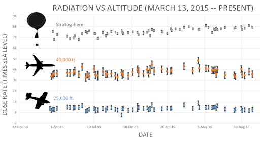
This plot displays radiation measurements not only in the stratosphere, but also at aviation altitudes. Dose rates are expessed as multiples of sea level. For instance, we see that boarding a plane that flies at 25,000 feet exposes passengers to dose rates ~10x higher than sea level. At 40,000 feet, the multiplier is closer to 50x. These measurements are made by our usual cosmic ray payload as it passes through aviation altitudes en route to the stratosphere over California.
What is this all about? Approximately once a week, Spaceweather.com and the students of Earth to Sky Calculus fly space weather balloons to the stratosphere over California. These balloons are equipped with radiation sensors that detect cosmic rays, a surprisingly "down to Earth" form of space weather. Cosmic rays can seed clouds, trigger lightning, and penetrate commercial airplanes. Furthermore, there are studies ( #1, #2, #3, #4) linking cosmic rays with cardiac arrhythmias and sudden cardiac death in the general population. Our latest measurements show that cosmic rays are intensifying, with an increase of more than 12% since 2015:
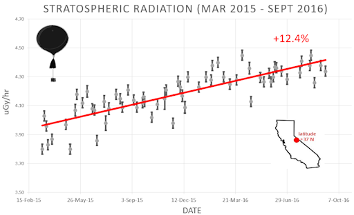
Why are cosmic rays intensifying? The main reason is the sun. Solar storm clouds such as coronal mass ejections (CMEs) sweep aside cosmic rays when they pass by Earth. During Solar Maximum, CMEs are abundant and cosmic rays are held at bay. Now, however, the solar cycle is swinging toward Solar Minimum, allowing cosmic rays to return. Another reason could be the weakening of Earth's magnetic field, which helps protect us from deep-space radiation.
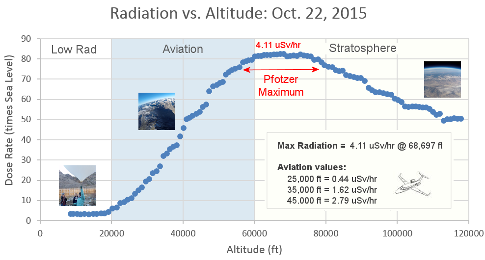
The radiation sensors onboard our helium balloons detect X-rays and gamma-rays in the energy range 10 keV to 20 MeV. These energies span the range of medical X-ray machines and airport security scanners.
The data points in the graph above correspond to the peak of the Reneger-Pfotzer maximum, which lies about 67,000 feet above central California. When cosmic rays crash into Earth's atmosphere, they produce a spray of secondary particles that is most intense at the entrance to the stratosphere. Physicists Eric Reneger and Georg Pfotzer discovered the maximum using balloons in the 1930s and it is what we are measuring today.
| | The official U.S. government space weather bureau |
| | The first place to look for information about sundogs, pillars, rainbows and related phenomena. |
| | Researchers call it a "Hubble for the sun." SDO is the most advanced solar observatory ever. |
| | 3D views of the sun from NASA's Solar and Terrestrial Relations Observatory |
| | Realtime and archival images of the Sun from SOHO. |
| | from the NOAA Space Environment Center |
| | a proud supporter of science education and Spaceweather.com |
| | the underlying science of space weather |
 | Find homes for sale in Ocala, Orlando and Tampa with the #1 real estate company in Central Florida Local Realty Service |
| | These links help Spaceweather.com stay online. Thank you to our supporters! |


