Learn to photograph Northern Lights like a pro. Sign up for Peter Rosen's Aurora Photo Courses in Abisko National Park, winner of the TripAdvisor Certificate of Excellence Award 2015. | | |
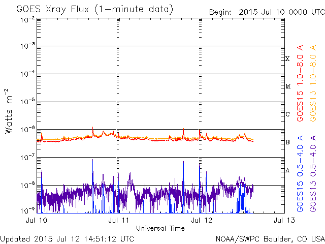
(ALMOST NO) CHANCE OF FLARES: Solar activity is very low. No sunspots are actively flaring and, as a result, the sun's X-ray output has flatlined. NOAA forecasters estimate a minuscule 1% chance of M- or X-class solar flares on July 16th. Solar flare alerts: text or voice.
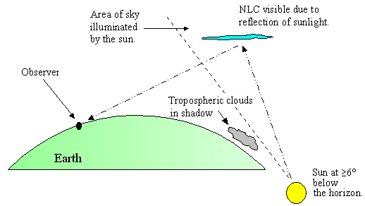
NOCTILUCENT CLOUDS: A bright bank of noctilucent clouds (NLCs) drifted over Europe last night (July 16th). "It was an unexpected and display. I was very excited," reports Ruslan Merzlyakov of Nykøbing Mors, Denmark, who recorded the moment with a self-portrait:
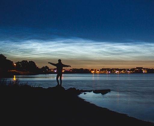
"You could say it was a 'moooo-ving experience,'" he adds.
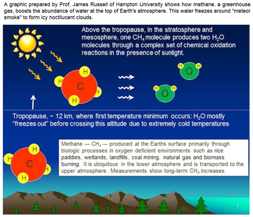
NLCs are Earth's highest clouds. Seeded by meteoroids, they float at the edge of space more than 80 km above the planet's surface. The clouds are very cold and filled with tiny ice crystals. When sunbeams hit those crystals, they glow electric-blue.
Noctilucent clouds first appeared in the 19th century after the eruption of super-volcano Krakatoa. At the time, people thought NLCs were caused by the eruption, but long after Krakatoa's ash settled, the clouds remained. In recent years, NLCs have intensified and spread with summer sightings as far south as Utah and Colorado. This could be a sign of increasing greenhouse gases in Earth's atmosphere.
Observing tips: Look west 30 to 60 minutes after sunset when the Sun has dipped 6o to 16o below the horizon. If you see luminous blue-white tendrils spreading across the sky, you may have spotted a noctilucent cloud.
Realtime NLC Photo Gallery
THE MYSTERIOUS MOUNTAINS OF PLUTO: New Horizons is starting to beam back some of the high-resolution photos it took during Tuesday's breakneck flyby of Pluto. One of the first images shows a mountain range with peaks jutting as high as 11,000 feet (3,500 meters) above the surface of the icy body:
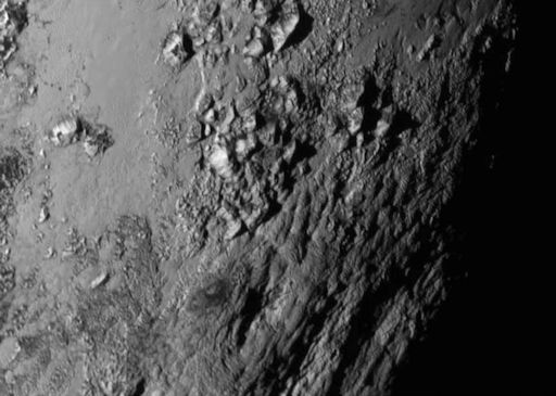
Spaceweather.com reader Philip Smith of Manorville, NY, has created an effective 3D representation of Pluto's mountains. Just cross your eyes slightly and they will practically leap out of your screen. Try it.
The mountains likely formed no more than 100 million years ago -- mere youngsters in a 4.56-billion-year-old solar system. This suggests Pluto may still be geologically active today.
"This is one of the youngest surfaces we've ever seen in the solar system," says Jeff Moore of the New Horizons Geology, Geophysics and Imaging Team (GGI) at NASA's Ames Research Center.
Unlike the icy moons of giant planets such as Jupiter and Saturn, Pluto cannot be heated by gravitational interactions with a much larger planetary body. Some other process must be generating its mountainous landscape.
"This may cause us to rethink what powers geological activity on many other icy worlds," says GGI deputy team leader John Spencer at SwRI.
This is just the beginning. It will take New Horizons as much as 9 months to transmit all the data it took during the flyby back to Earth. Stay tuned for more surprises.
Realtime Pluto Photo Gallery
SWx FORECAST VIDEO: Harvard undergraduate Matthew Cappucci has created another forecast video for readers of spaceweather.com. Check it out!
TRANSCONTINENTAL SPACE WEATHER BALLOON LAUNCH: On Monday, July 20th, the students of Earth to Sky Calculus, in collaboration with the University of New Hampshire, will conduct the first-ever transcontinental launch of Space Weather Balloons. The group will be split in two, half in New Hampshire and half in California, and release balloons simultaneously 2947 miles apart. The purpose of the experiment is to discover how Earth's atmosphere responds to solar activity on continental scales.
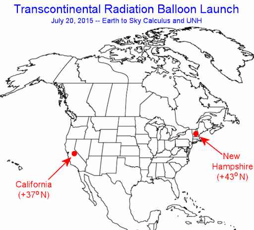
The payload of each balloon will be equipped with an array of cosmic ray sensors capable of measuring measure neutrons, X-rays and gamma-rays at altitudes as high as 120,000 ft.
Regular readers know that we have been launching "radiation balloons" for nearly two years. In the past 6 months alone, the program has detected three disturbances in the stratosphere caused by CMEs and geomagnetic storms. So far the measurements have been localized to California and Nevada. The July 20th experiment is a step toward expanding our program across North America.
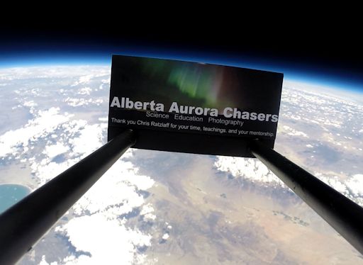
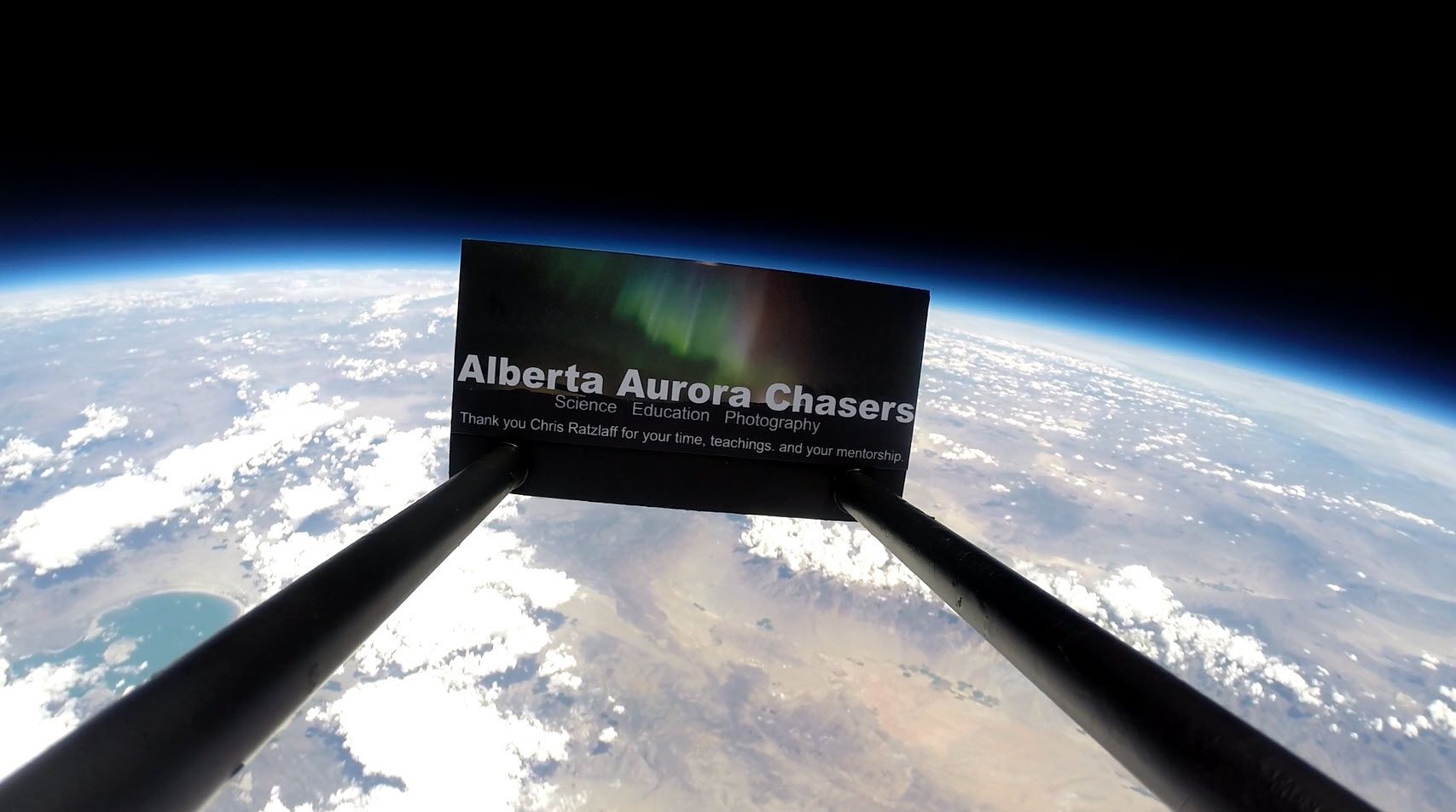
CROWD-FUNDED RESEARCH: The California half of the Transcontinental Launch is possible thanks to a $500 donation from the Alberta Aurora Chasers. To say "thanks", we flew their logo 111,400 feet above Earth's surface:
Update: White Mountain Science, Inc. has just agreed to sponsor the New Hampshire half of the Transcontinental Launch. Readers, if you would like to join them in supporting this crowd-funded research, and see your logo or favorite photo at the edge of space, please contact Dr. Tony Phillips to make arrangements.
Realtime Space Weather Photo Gallery
Realtime Aurora Photo Gallery
Realtime Sprite Photo Gallery
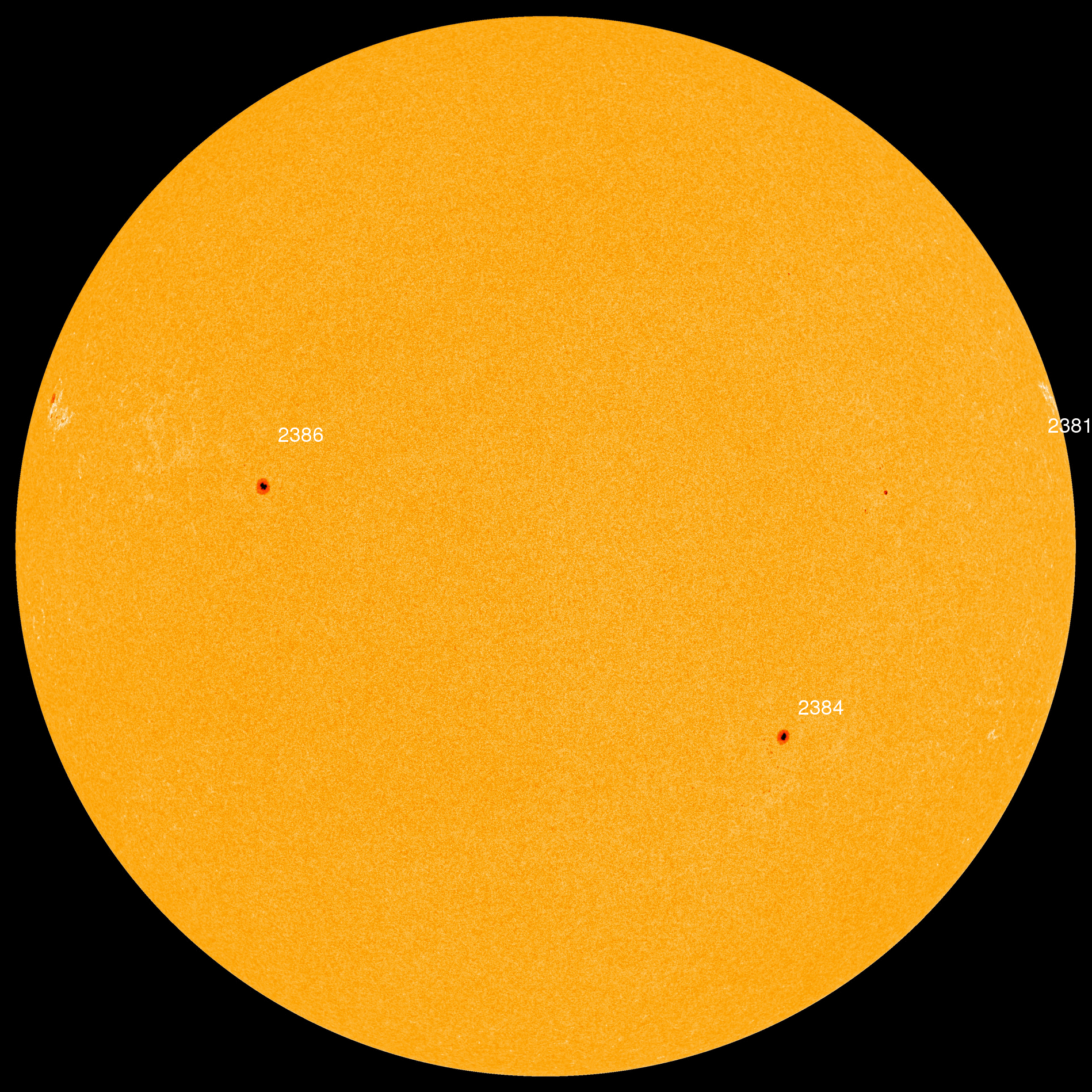
Every night, a network of NASA all-sky cameras scans the skies above the United States for meteoritic fireballs. Automated software maintained by NASA's Meteoroid Environment Office calculates their orbits, velocity, penetration depth in Earth's atmosphere and many other characteristics. Daily results are presented here on Spaceweather.com.
On Jul. 16, 2015, the network reported 69 fireballs.
(69 sporadics)
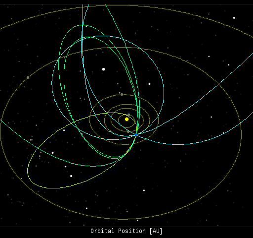
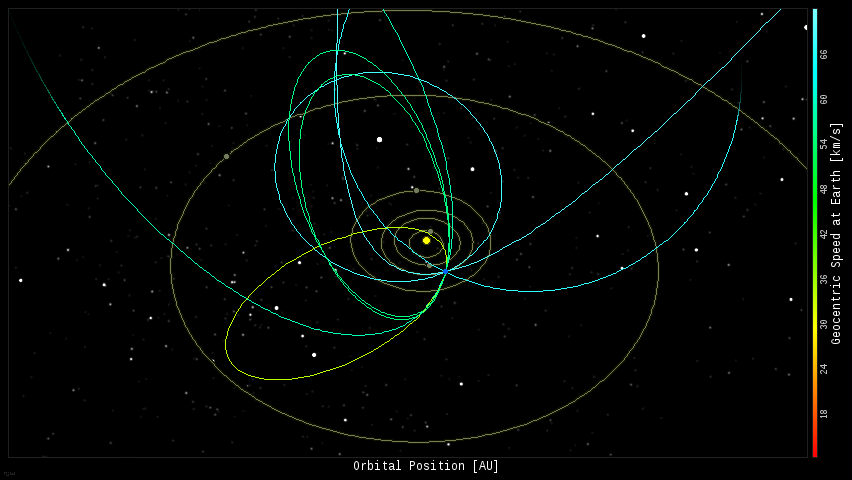
In this diagram of the inner solar system, all of the fireball orbits intersect at a single point--Earth. The orbits are color-coded by velocity, from slow (red) to fast (blue). [Larger image] [movies]
Potentially Hazardous Asteroids (
PHAs) are space rocks larger than approximately 100m that can come closer to Earth than 0.05 AU. None of the known PHAs is on a collision course with our planet, although astronomers are finding
new ones all the time.
On July 16, 2015 there were potentially hazardous asteroids.
Notes: LD means "Lunar Distance." 1 LD = 384,401 km, the distance between Earth and the Moon. 1 LD also equals 0.00256 AU. MAG is the visual magnitude of the asteroid on the date of closest approach. | | The official U.S. government space weather bureau |
| | The first place to look for information about sundogs, pillars, rainbows and related phenomena. |
| | Researchers call it a "Hubble for the sun." SDO is the most advanced solar observatory ever. |
| | 3D views of the sun from NASA's Solar and Terrestrial Relations Observatory |
| | Realtime and archival images of the Sun from SOHO. |
| | from the NOAA Space Environment Center |
| | the underlying science of space weather |
| | Web-based high school science course with free enrollment |


