Learn to photograph Northern Lights like a pro. Sign up for Peter Rosen's Aurora Photo Courses in Abisko National Park, winner of the TripAdvisor Certificate of Excellence Award 2015. | | |
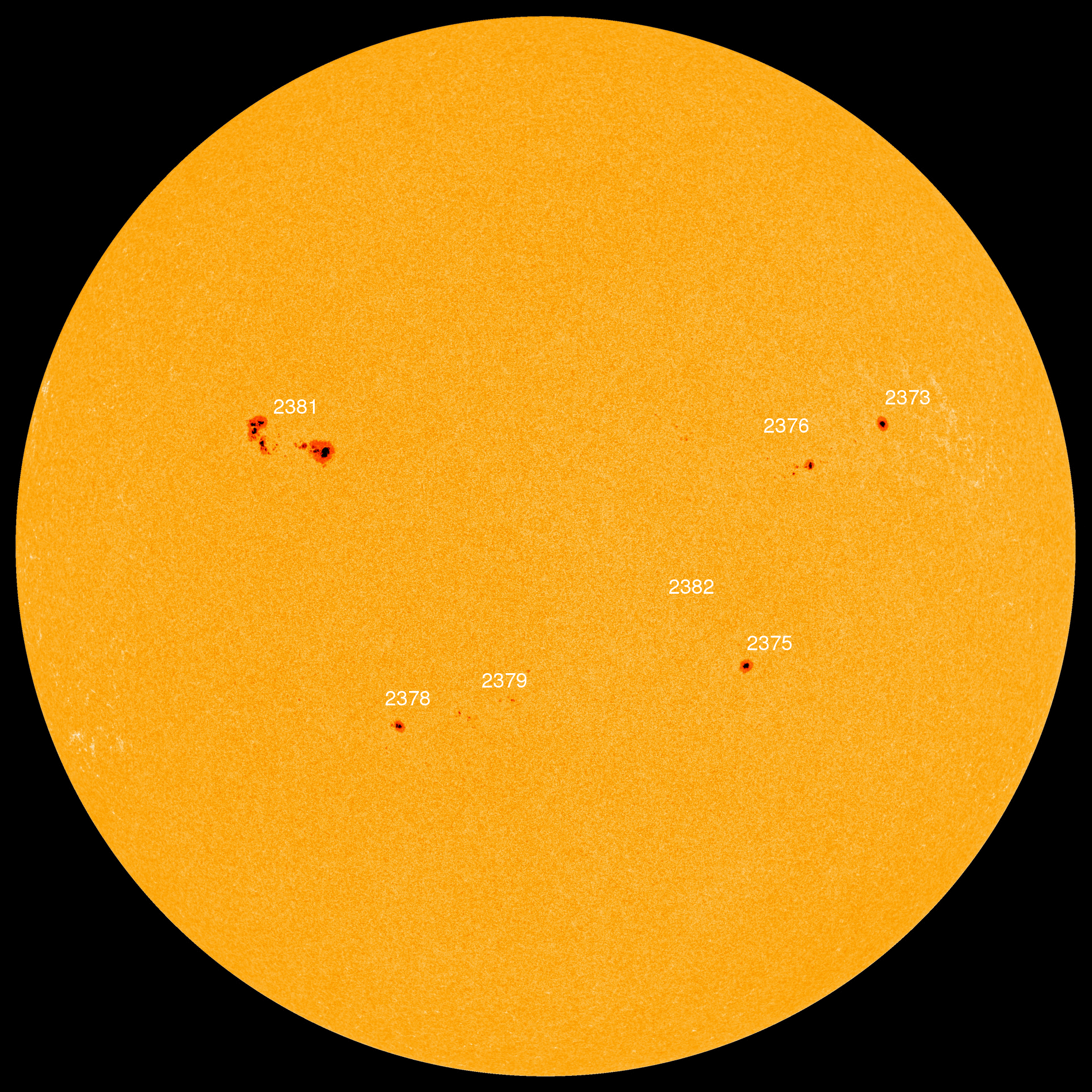
QUIET WITH A CHANCE OF FLARES: Solar activity is low, but the quiet might not last. Fast-growing sunspot AR2381 has an unstable magnetic field that harbors energy for strong solar flares. NOAA forecasters have boosted the odds of an M-class eruption on July 7th to 45%. Solar flare alerts: text or voice.
NOCTILUCENT CLOUDS: Summer is the season for noctilucent (night-shining) clouds, and the month of July is often when they are at their best. Last night, Jüri Voit photographed these electric-blue ripples over Estonia:
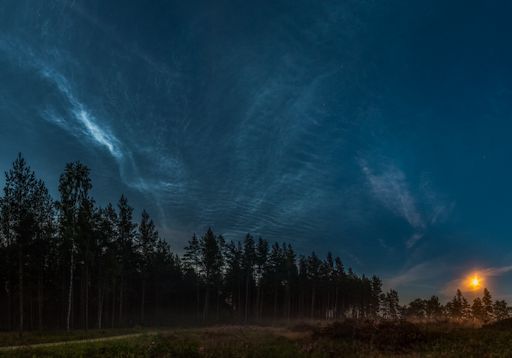
"The combination of moonlight and noctilucent clouds (NLCs) was magical," says Voit. "What a night!"
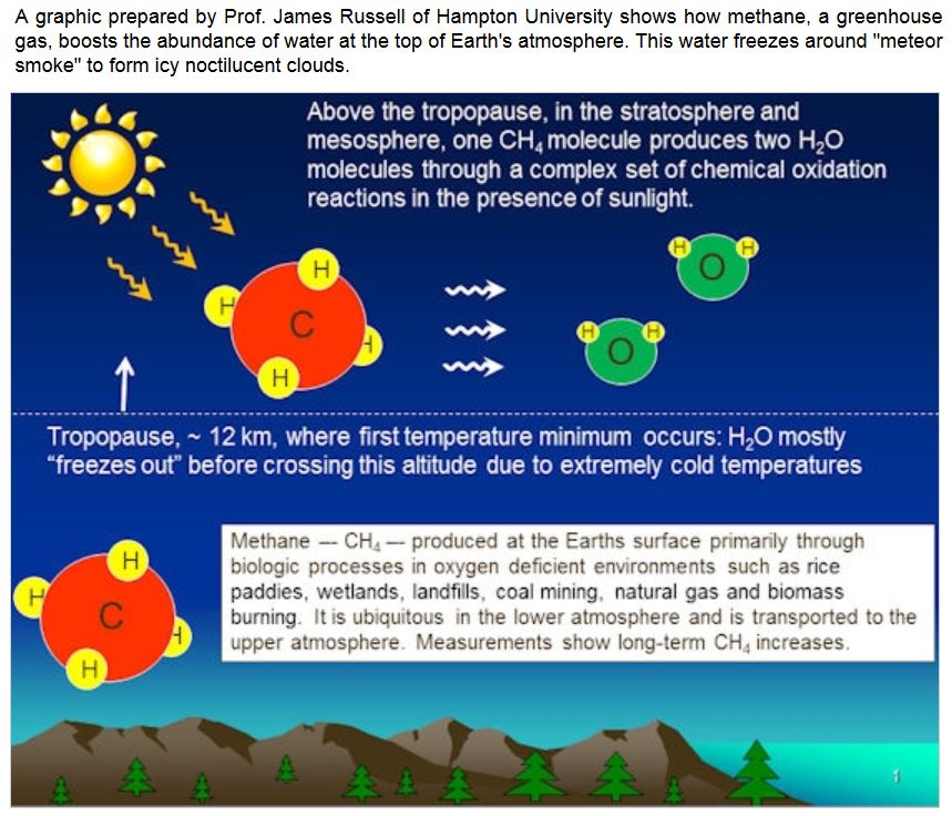
NLCs are Earth's highest clouds. Seeded by meteoroids, they float at the edge of space more than 80 km above the planet's surface. The clouds are very cold and filled with tiny ice crystals. When sunbeams hit those crystals, they glow electric-blue.
Noctilucent clouds first appeared in the 19th century after the eruption of super-volcano Krakatoa. At the time, people thought NLCs were caused by the eruption, but long after Krakatoa's ash settled, the clouds remained. In recent years, NLCs have intensified and spread with summer sightings as far south as Utah and Colorado. This could be a sign of increasing greenhouse gases in Earth's atmosphere.
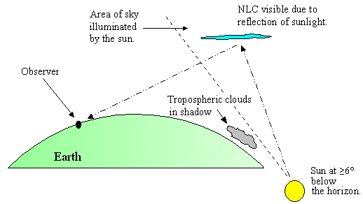
Observing tips: Look west 30 to 60 minutes after sunset when the Sun has dipped 6o to 16o below the horizon. If you see luminous blue-white tendrils spreading across the sky, you may have spotted a noctilucent cloud.
Realtime NLC Photo Gallery
CANADIAN WILDFIRE SEASON: "Minnesota has several unusual seasons: winter, mosquito, and road construction, to name a few," says Aaron Seefeld of Hastings, MN. "Over the last few years, another season has emerged - Canadian wildfire season. The skies turn grey and objects in the sky turn red, if they're visible at all." He photographed this smoke-reddened Moon on July 3rd:
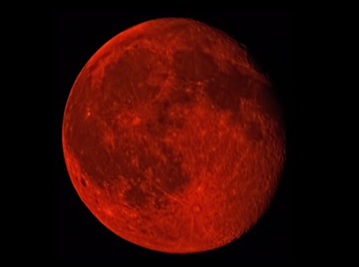
"On the night of 3 July, a waning full Moon was masked by the smoke particles hanging in the air," says Seefel. "It was supposed to rise at 22:02 local time, but - despite 'clear' skies - didnt appear until close to 23:00. When it did start to emerge, it was deep red."
The smoke plumes from Canadian wildfires are so large and dense that NASA satellites have been photographing them from space. Here is an example from the Terra satellite on June 30th.
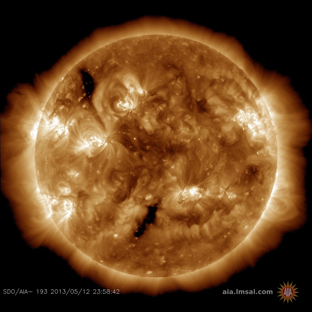
In addition to reddening the Moon, Canadian smoke is also dimming the sun, allowing big sunspots like AR2381 to pop into view at sunset. Charles Russell sends this report from Greenville, Michigan: "The thick smoke in the upper atmosphere as a result of the wildfires in Canada acted as a filter, which allowed me to see and capture this photo with clusters of sunspots clearly visible on the solar disk!"
"Canadian wildfire season" is affecting the skies of more than a dozen US states. Monitor the realtime photo gallery for more smokey sightings.
Realtime Space Weather Photo Gallery
RED SPRITES OVER EUROPE: As northern summer unfolds, electrical storms are rumbling across Europe. After nightfall, red sprites can be seen dancing across the cloudtops. Petr Horálek of Ustupky, Czech Republic, photographed these specimens on July 6th:
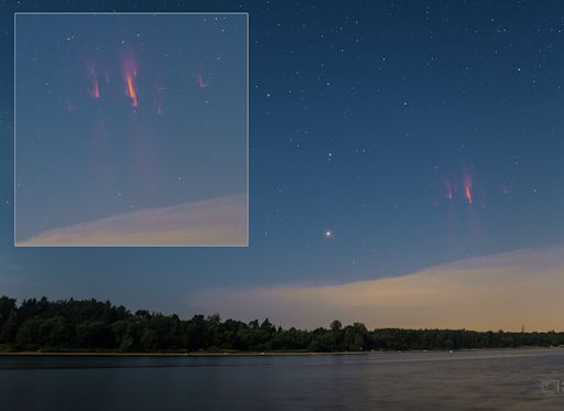
"There were strong convective thunderstorms visible from my observing site at the Seč reservoir," says Horálek. "I waited almost 3 hours--and finally the sprites appeared. I could see one of them with my naked eye even in strong moonlight."
"Sprites are a true space weather phenomenon," says lightning scientist Oscar van der Velde of the Technical University of Catalonia, Spain. "They develop in mid-air around 80 km altitude (the same altitude as noctilucent clouds and meteors). This happens when a fierce lightning bolt draws lots of charge from a cloud near Earth's surface. Electric fields [shoot] to the top of Earth's atmosphere--and the result is a sprite. The entire process takes about 20 milliseconds." Some researchers believe that cosmic rays play a role, too: subatomic particles from deep space strike the top of Earth's atmosphere, providing the "spark" that ignites this strange form of upward lightning.
Although sprites have been seen for at least a century, most scientists did not believe they existed until after 1989 when sprites were photographed by cameras onboard the space shuttle. Now "sprite chasers" routinely photograph sprites from their own homes. Give it a try!
Realtime Sprite Photo Gallery
Realtime Aurora Photo Gallery
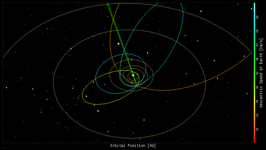
Every night, a network of NASA all-sky cameras scans the skies above the United States for meteoritic fireballs. Automated software maintained by NASA's Meteoroid Environment Office calculates their orbits, velocity, penetration depth in Earth's atmosphere and many other characteristics. Daily results are presented here on Spaceweather.com.
On Jul. 7, 2015, the network reported 9 fireballs.
(9 sporadics)
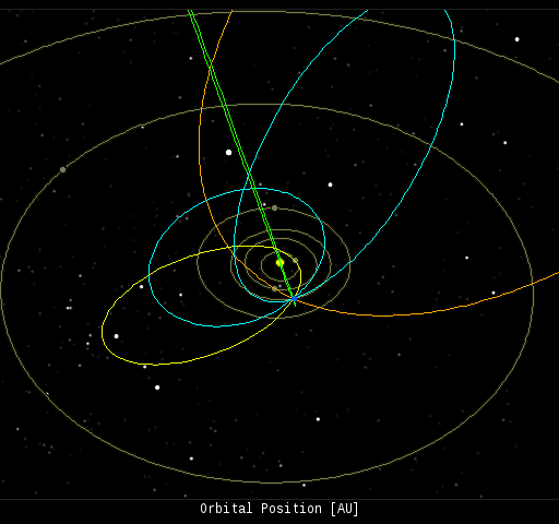
In this diagram of the inner solar system, all of the fireball orbits intersect at a single point--Earth. The orbits are color-coded by velocity, from slow (red) to fast (blue). [Larger image] [movies]
Potentially Hazardous Asteroids (
PHAs) are space rocks larger than approximately 100m that can come closer to Earth than 0.05 AU. None of the known PHAs is on a collision course with our planet, although astronomers are finding
new ones all the time.
On July 7, 2015 there were potentially hazardous asteroids.
Notes: LD means "Lunar Distance." 1 LD = 384,401 km, the distance between Earth and the Moon. 1 LD also equals 0.00256 AU. MAG is the visual magnitude of the asteroid on the date of closest approach. | | The official U.S. government space weather bureau |
| | The first place to look for information about sundogs, pillars, rainbows and related phenomena. |
| | Researchers call it a "Hubble for the sun." SDO is the most advanced solar observatory ever. |
| | 3D views of the sun from NASA's Solar and Terrestrial Relations Observatory |
| | Realtime and archival images of the Sun from SOHO. |
| | from the NOAA Space Environment Center |
| | the underlying science of space weather |
| | Web-based high school science course with free enrollment |


